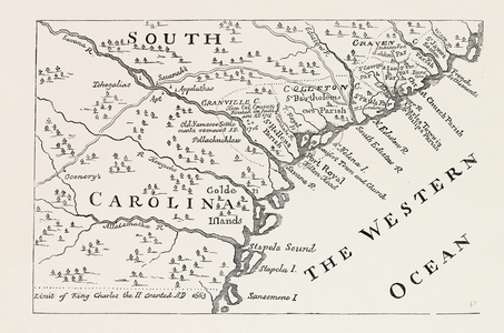
Image of Map of South Carolina in 1730 (litho) by Moll, Hermann (fl.1678-1732) (after)
{"event":"pageview","page_type1":"catalog","page_type2":"image_page","language":"en","user_logged":"false","user_type":"ecommerce","nl_subscriber":"false"}
{"event":"ecommerce_event","event_name":"view_item","event_category":"browse_catalog","ecommerce":{"items":[{"item_id":"PNP351120","item_brand":"other","item_category":"illustration","item_category2":"out_of_copyright","item_category3":"standard","item_category4":"moll_hermann_fl_1678_1732_after","item_category5":"not_balown","item_list_name":"search_results","item_name":"map_of_south_carolina_in_1730_litho","item_variant":"undefined"}]}}
Search our collection by uploading an image.
Drag & Drop an image Click to browse your device
This search will return exact matches only. For best results:
Processing search results
Choose your Colors
Add up to 5 colors and slide the dividers to adjust the composition
Add keywords to refine your results
Searching for a particular field
Field Search term Example
Asset title title: title:pony Asset title and keywords ~ ~pony Asset description text description: description:london Agency prefix prfx: or $ prfx:lal or $LAL Asset id imageid: imageid:250297 or imageid:[2500 TO 4000] Agency name coll: coll:history Medium medium: medium:oil Century century: century:20th Keywords kw: kw:dog Artist name artist: or ? artist:monet or ?monet Artist nationality ?? ??French Creator ID creatorid: creatorid:37 Location loc: or @ loc:exeter or @exeter Classification class: or # class:57 or #57. Use # for unclassified assets Year year: year:1850 or year:[1700 TO 1800]
Metadata Block (Hidden)
Contact us for further help
High res file dimension
Search for more high res images or videos
Map of South Carolina in 1730 (litho)
 by Moll, Hermann (fl.1678-1732) (after)")